 |
||||
|
|
||||
|
|
|
|
|
|
|
|
|
|
|
|
|
|
|
|
|
French Huguenots, Germans |
|
|
|
|
|
|
|
|
|
|
|
|
|
|
|
|
|
|
|
|
|
|
|
|
|||
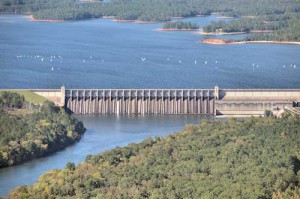 Lake Thurmond and Clarks Hill Dam - McCormick County, SC In 1769, legislation created seven "overarching Districts" in the state of South Carolina. The Ninety-Six District encompassed upcountry lands bordering the Cherokee nation. In 1785, this area was divided into six new counties, which included Abbeville and Edgefield counties, followed by another division in 1897 which created Greenwood County. In 1916, after a 21 year effort, McCormick County was formed out of parts of Abbeville, Greenwood, and Edgefield Counties. It is the state’s smallest and second youngest county. McCormick County lies geographically within the northwestern plateau in the foothills of the piedmont and has the greatest percentage of forest land (88%) of any South Carolina county. Our history and the patterns of human activity were shaped strongly by our geography, modes of transportation and the government (colonial and modern). The earliest occupants, prehistoric Indians followed by the Westos, Yuchis, and Cherokee Indians, used the lands for hunting and fishing. In 1540, Hernando DeSoto crossed their paths searching for gold that remained hidden for another 300 years. In the 1700s, white hunters, cattle drovers, and Indian traders traversed the area. By 1715, there was a man named Stevens who had cow pens on the creek now named for him. In 1756, the Calhouns, pioneers of Scots-Irish descent, built the first group settlement on Long Cane Creek, the boundary of the Cherokee Nation. The French Huguenots, the next group, settled New Bordeaux and New Rochelle (click on the links above) after they came to this area in 1764 looking not for gold but for religious freedom. In search of freedom from the Crown, the first overt act of the American Revolution in South Carolina occurred at Fort Charlotte near Mt. Carmel on July 12, 1775. Later the settlers from the Long Cane area would also participate in the battles of nearby Ninety-Six and Cowpens. After the American Revolution, a plantation economy developed with crops transported down the Savannah River on Petersburg boats. The children of the owners became some of South Carolina's most famous statesmen. W. B. "Billy" Dorn, a descendant of the German Palatines who settled Londonborough in 1764-65, finally discovered the "gold" in 1851. As slave labor wasn’t available after the American Civil War, the output of the mines was greatly diminished. Cyrus Hall McCormick, inventor of the reaper, invested in Dorn’s Mines in 1869 and purchased the property in 1871. After fruitless attempts to make the mines profitable, he closed them in 1883. In 1879, McCormick invested in the Augusta & Knoxville Railroad, then in 1880 he invested in the Savannah Valley Railroad, to persuade them to build new lines through his property. Because of cotton and poultry production and the arrival of the railroad, the town of McCormick and the surrounding area soon began to flourish. As a result of the prosperity, a committee was formed to have a separate county created. The project, a twenty-one (21) year effort, was successful in 1916. As Calhoun, their first choice for the name, had been taken, the committee again relied on McCormick for the county name. Although Nettie McCormick was a frequent visitor, it should be noted that Cyrus McCormick never stepped foot in the town or on any of the land that bears his name.  Sumter National Forest - McCormick County, SC Greatly affected by the boll weevil and the Great Depression, landowners looked for a way out by selling their land to the government. The Civilian Conservation Corps (CCC) planted the pine trees that now make up the Sumter National Forest. To resolve the flooding of Augusta, Geortia, the government stepped in again. The U.S. Army Corps of Engineers obtained land in the 1940s to build Clarks Hill Dam and Lake on the Savannah River. Lake Thurmond, as it is now known, covers 70,000 acres and provides hydro-electric power, recreation and 1,200 miles of shoreline. The county’s economic base relies heavily on the textile industry and on its natural resources for timber production and tourism. McCormick County and its county seat, the town of McCormick, were named for inventor Cyrus Hall McCormick (1809-1884). The county was formed in 1916 from parts of Edgefield, Abbeville, and Greenwood counties. This area was settled in the mid-eighteenth century by Scots-Irish, French Huguenot, and German farmers. Some of the early inhabitants were massacred by Cherokee Indians at Long Cane in 1760, and the British subsequently built Fort Charlotte to protect the region; this fort was one of the first seized by the Patriots at the beginning of the Revolutionary War. In 1764, Hillsborough Township was established and settled by 212 French Huguenots - they even founded two small towns, New Bordeaux and New Rochelle - but, these did not survive into the modern era. These settlements were in what is now McCormick County. About 1850, gold was discovered where the town of McCormick now stands. The Dorn Gold Mine, which later also produced manganese, was bought by Cyrus McCormick in 1871; he donated land for the town, which was named for him in 1882. This mine continued to operate until the 1930s. Several prominent South Carolinians have resided in the area that is now McCormick County, including Governor and U.S. Senator George McDuffie (1790-1851), Unionist leader James Louis Petigru (1789-1863), and Moses Waddel (1770-1840), who taught many of the future leaders of the state at his Willington Academy. McCormick County was formed in 1916 from Edgefield, Greenwood, and Abbeville counties, and was named in honor of Cyrus H. McCormick, of reaper fame, who owned thousands of acres of land in and around the present county seat. It is in the western part of the state on the Savannah River, in the Third Congressional district and Eleventh judicial circuit. It has an area of 379 square miles, with a population of 16,444 in 1920, estimated for 1925 at 16,984. The surface is moderately rolling to level with red clay land in the upper part of the county and sandy soil with clay subsoil in the lower part. The growing season is about 235 days. Little River crosses the county and the Savannah River borders it on the west. Agriculture is the chief industry of the county. Cotton is the principal crop, with other crops, such as corn, grain, and hay, growing in importance each year. The lower part of the country is noted for its fine peach orchards. Peaches are shipped south to Florida and as far north as Canada. The Bermuda pasture lands along the rivers and creeks make sheep raising a profitable business. There are 56 commercial poultry farms shipping thousands of dozens of eggs and chickens by truck, express, and car lots. Lumbering is an important industry. Lumber and cord wood are shipped daily. The abandoned mines of manganese and gold have yielded nearly a million dollars worth of ore. The Charleston & Western Carolina Railway traverses the county, and a branch line runs through the western part from the county seat. The total railroad mileage is 52. Topsoil roads connect all towns with the state highway which crosses the county at its longest point. There are 55 miles of topsoil road in the county. McCormick County has two accredited high schools, one at Plum Branch, the other at McCormick. The McCormick school operates four busses. A consolidated school is in the lower part of the county. A number of historic places are in the territory included in McCormick's borders. New Bordeaux was settled by the French Huguenots 94 years after Charleston was settled. One of these settlers, Dr. John De La Howe, left an estate of 1,700 acres and his home place, "Lethe," to be used as an industrial school for orphans of the county. This, the John De La Howe Industrial school, near Bordeaux, possibly the first of its kind in the country, is now controlled by the state. A new building was recently added to the plant. De La Howe's tomb, in a lonely place on Little River, has riveted on its iron door an inscription in French and the date, 1797. The place of the Calhoun Massacre by the Indians in 1760 is in the western part of the county. Prominent in the early days were the Calhouns, Petigrus, McKies, Middletons, and others. The towns are along the railroad. McCormick, the county seat, is the largest town, with a population of 1,284 in 1920. It is also the largest town between Greenwood and Augusta. The citizens have recently completed another high school building and installed lights and water. The Southeastern Egg Laying Contest grounds, where 1,000 thoroughbred hens are housed, is here. The undeveloped water power of the Savannah and Little rivers offers opportunities for manufacturing interests. A great project on the Savannah is described elsewhere in the article about water power. The climate and soil are suitable for nearly all kinds of agriculture and a county agent is ever ready to assist the farmers and encourage diversification. Immediately above, published in "South Carolina: A Handbook," prepared by The Department of Agriculture, Commerce, and Industries and Clemson College, Columbia, South Carolina, 1927. In the Public Domain. [with minor edits] |
|||
 |
 |
© 2021 - J.D. Lewis - PO Box 1188 - Little River, SC 29566 - All Rights Reserved